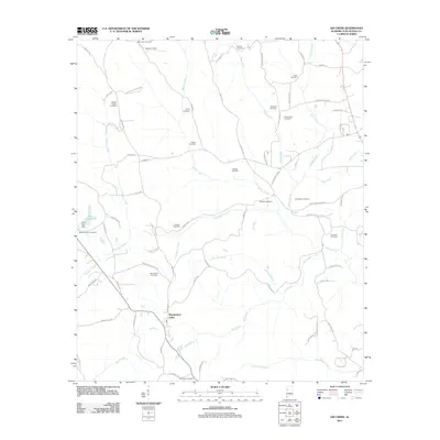
2011 Map of Gin Creek
USGS Topo · Published 2011About this map
Binion Creek and Gin Creek carve through this rural corner of Alabama, where the landscape is defined by a dense network of family cemeteries and small waterways. These burial grounds, including Wommack Cemetery, Rogers Cemetery, and Hendrix Cemetery, serve as markers for generations of local families throughout the backcountry. The map reveals a transition from these early homestead landmarks to more modern recreational and industrial footprints, such as Pine Lake and its associated Pine Lake Dam. In the southern portion of the quadrangle, the convergence of Mud Creek and Tilly Branch near the Montgomery Lakes indicates a shift toward flatter, water-rich bottomlands. This 2011 survey captures the area’s enduring character, where narrow roads like Old Fayette Rd and Murk Montgomery Rd still follow the contours of the drainage basins.
Find a feature on this map
79 named features on this map. Tap any name to fly to it.
Don’t see what you’re looking for? This feature index may not catch every label — zoom into the map to look around manually.
Map Details
Editions of this 2011 Gin Creek Map
This is the sole edition of this map. No revisions or reprints were ever made.
Other maps of this area

1926 · Samantha
USGS Topo · 1:48,000

1928 · Samantha
USGS Topo · 1:62,500

1953 · Birmingham
USGS Topo · 1:250,000

1956 · Birmingham
USGS Topo · 1:250,000

1957 · Birmingham
USGS Topo · 1:250,000

1967 · Brownville
USGS Topo · 1:24,000

1967 · Newtonville
USGS Topo · 1:24,000

1967 · Elrod
USGS Topo · 1:24,000
1967 · New Lexington
USGS Topo · 1:24,000
1967 · Berry SE
USGS Topo · 1:24,000