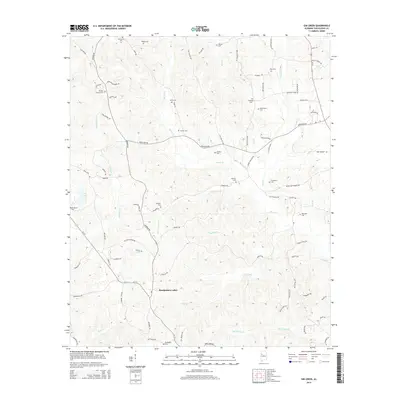
2014 Map of Gin Creek
USGS Topo · Published 2014About this map
Gin Creek and the surrounding drainage basin of Binion Cr define this rural landscape in Tuscaloosa County. The area is characterized by a dense distribution of family and community burial grounds, including Wommack Cem, Kemp Cem, and Wilson Cem, which provide significant genealogical anchor points for the region. These sites are linked by a network of winding roads like Northside Rd and Old Fayette Rd, following the contours of the Alabama hills.
Find a feature on this map
89 named features on this map. Tap any name to fly to it.
Don’t see what you’re looking for? This feature index may not catch every label — zoom into the map to look around manually.
Map Details
Editions of this 2014 Gin Creek Map
This is the sole edition of this map. No revisions or reprints were ever made.
Other maps of this area

1926 · Samantha
USGS Topo · 1:48,000

1928 · Samantha
USGS Topo · 1:62,500

1953 · Birmingham
USGS Topo · 1:250,000

1956 · Birmingham
USGS Topo · 1:250,000

1957 · Birmingham
USGS Topo · 1:250,000

1967 · Brownville
USGS Topo · 1:24,000

1967 · Newtonville
USGS Topo · 1:24,000

1967 · Elrod
USGS Topo · 1:24,000
1967 · New Lexington
USGS Topo · 1:24,000
1967 · Berry SE
USGS Topo · 1:24,000