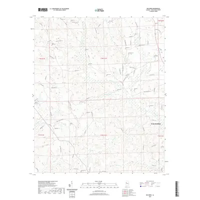
2020 Map of Gin Creek
USGS Topo · Published 2020About this map
The rolling landscape of northern Tuscaloosa County is defined by a dense network of family and community cemeteries that trace the settlement patterns of this Alabama region. Numerous burial grounds, including Bethabara Cem, Nazareth Cem, and Phillips Chapel Cem, are scattered across the terrain, often located near historical homesteads and rural crossroads. The topography is carved by a system of tributaries feeding into larger water bodies beyond the map’s edge, with Binion Cr, Wolf Cr, and Gin Cr creating a series of ridges and hollows.
Find a feature on this map
92 named features on this map. Tap any name to fly to it.
Don’t see what you’re looking for? This feature index may not catch every label — zoom into the map to look around manually.
Map Details
Editions of this 2020 Gin Creek Map
This is the sole edition of this map. No revisions or reprints were ever made.
Other maps of this area

1926 · Samantha
USGS Topo · 1:48,000

1928 · Samantha
USGS Topo · 1:62,500

1953 · Birmingham
USGS Topo · 1:250,000

1956 · Birmingham
USGS Topo · 1:250,000

1957 · Birmingham
USGS Topo · 1:250,000

1967 · Brownville
USGS Topo · 1:24,000

1967 · Newtonville
USGS Topo · 1:24,000

1967 · Elrod
USGS Topo · 1:24,000
1967 · New Lexington
USGS Topo · 1:24,000
1967 · Berry SE
USGS Topo · 1:24,000