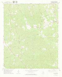
1978 Map of Gin Creek
USGS Topo · Published 1979About this map
Binion Creek and Wolf Creek define the drainage of this rural landscape in northern Tuscaloosa County during the mid-1970s. The settlement pattern is characterized by scattered family homesteads, rural churches, and numerous small cemeteries, many bearing the names of local families such as the Espy, Gilliam, and Edmondson families. The presence of Northside High Sch and Walker Sch near the eastern margin suggests a focal point for the surrounding community, while the community of Bethabara anchors the southern portion of the sheet. Modern utility infrastructure is visible in the form of Water Tanks and Sewage Disposal Ponds, contrasting with the traditional rural network of unpaved roads like Old Fayette Road and Thornton Road. The map provides a detailed view of the terrain before later suburban expansion, tracing the headwaters of Gin Creek and Sam Norris Branch.
Find a feature on this map
48 named features on this map. Tap any name to fly to it.
Don’t see what you’re looking for? This feature index may not catch every label — zoom into the map to look around manually.
Map Details
Editions of this 1978 Gin Creek Map
This is the sole edition of this map. No revisions or reprints were ever made.
Other maps of this area

1926 · Samantha
USGS Topo · 1:48,000

1928 · Samantha
USGS Topo · 1:62,500

1953 · Birmingham
USGS Topo · 1:250,000

1956 · Birmingham
USGS Topo · 1:250,000

1957 · Birmingham
USGS Topo · 1:250,000

1967 · Brownville
USGS Topo · 1:24,000

1967 · Newtonville
USGS Topo · 1:24,000

1967 · Elrod
USGS Topo · 1:24,000
1967 · New Lexington
USGS Topo · 1:24,000
1967 · Berry SE
USGS Topo · 1:24,000