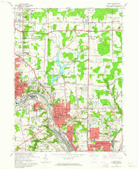
1962 Map of Girard
USGS Topo · Published 1964About this map
The industrial corridor of the Mahoning River dominates this early 1960s study of the Trumbull and Mahoning county line. Heavy industry and transportation networks are the primary features, with a massive Slag Dump and multiple Mines defining the periphery of Girard and McDonald. The era's reliance on rail is evident in the dense convergence of the Pennsylvania, Baltimore and Ohio, and Erie-Lackawanna lines, which service the riverside mills and furnaces. Away from the river, the landscape transitions into established residential neighborhoods and institutional grounds like the Ursuline Convent and Belmont Park Cemetery. This map records the peak of the region's mid-century manufacturing footprint, showing the integration of workforce housing in places like McKinley Heights and Belmont Park with the nearby steel and coal infrastructure that fueled the local economy.
Find a feature on this map
93 named features on this map. Tap any name to fly to it.
Don’t see what you’re looking for? This feature index may not catch every label — zoom into the map to look around manually.
Map Details
Editions of this 1962 Girard Map
4 editions found
Other maps of this area

1905 · Bristolville
USGS Topo · 1:62,500

1906 · Youngstown
USGS Topo · 1:62,500

1907 · Kinsman
USGS Topo · 1:62,500

1907 · Bristolville
USGS Topo · 1:62,500

1908 · Youngstown
USGS Topo · 1:62,500

1908 · Warren
USGS Topo · 1:62,500

1950 · Cleveland
USGS Topo · 1:250,000

1951 · Campbell
USGS Topo · 1:24,000

1951 · Youngstown
USGS Topo · 1:24,000

1952 · Canfield
USGS Topo · 1:24,000