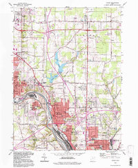
1994 Map of Girard
USGS Topo · Published 1997About this map
Industrial history and mid-century suburban expansion define this study of the corridor between Niles and Youngstown. The Mahoning River serves as the primary artery for the region's heavy industry, evidenced by the massive Slag Dump and Power Plant installations near McDonald and Girard. These industrial zones are bordered by established neighborhoods and numerous community institutions, including Girard Liberty Union Cemetery and a high density of local schools like North Ave Sch and Mines Sch.
Find a feature on this map
77 named features on this map. Tap any name to fly to it.
Don’t see what you’re looking for? This feature index may not catch every label — zoom into the map to look around manually.
Map Details
Editions of this 1994 Girard Map
This is the sole edition of this map. No revisions or reprints were ever made.
Other maps of this area

1905 · Bristolville
USGS Topo · 1:62,500

1906 · Youngstown
USGS Topo · 1:62,500

1907 · Kinsman
USGS Topo · 1:62,500

1907 · Bristolville
USGS Topo · 1:62,500

1908 · Youngstown
USGS Topo · 1:62,500

1908 · Warren
USGS Topo · 1:62,500

1950 · Cleveland
USGS Topo · 1:250,000

1951 · Campbell
USGS Topo · 1:24,000

1951 · Youngstown
USGS Topo · 1:24,000

1952 · Canfield
USGS Topo · 1:24,000