
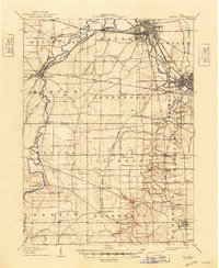
1908 Map of Warren
USGS Topo · Published 1937About this map
The Mahoning River carves a winding path through this industrial and agricultural landscape at the turn of the century, serving as the primary corridor for a dense concentration of rail lines. Major hubs like Warren and Niles show the early footprints of their urban grids, while smaller rail-dependent settlements such as Leavittsburg and Phalanx Station mark the junctions of the Erie RR and Baltimore and Ohio RR systems.
Find a feature on this map
70 named features on this map. Tap any name to fly to it.
Don’t see what you’re looking for? This feature index may not catch every label — zoom into the map to look around manually.
Map Details
Editions of this 1908 Warren Map
2 editions found
Other maps of this area

1905 · Bristolville
USGS Topo · 1:62,500

1905 · Garrettsville
USGS Topo · 1:62,500

1906 · Youngstown
USGS Topo · 1:62,500

1906 · Ravenna
USGS Topo · 1:62,500

1907 · Kinsman
USGS Topo · 1:62,500

1907 · Bristolville
USGS Topo · 1:62,500

1907 · Garrettsville
USGS Topo · 1:62,500

1907 · Columbiana
USGS Topo · 1:62,500

1908 · Youngstown
USGS Topo · 1:62,500

1908 · Ravenna
USGS Topo · 1:62,500