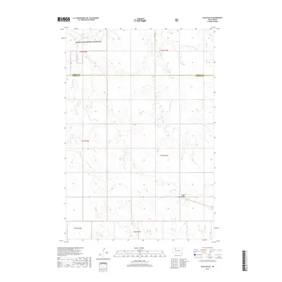
2017 Map of Glad Valley
USGS Topo · Published 2017About this map
Glad Valley anchors the southern portion of this Ziebach County landscape, situated where the high plains meet the intricate drainage systems of the Missouri River plateau. The northern reaches are defined by the Grand River National Grassland, a vast public expanse that preserves the native prairie ecosystem. This area is characterized by a complex network of seasonal watercourses, most notably Twin Butte Cr and the diverging branches of W Fork E Twin Butte Cr and E Fork E Twin Butte Cr. These creek beds create a rugged topography of draws and ridges that stand in contrast to the level sections of the township grid. The presence of Co Rd 33.5 provides one of the few primary transit corridors through this isolated section of the South Dakota backcountry, tracing a path across the Corson Co Ziebach Co boundary line.
Find a feature on this map
13 named features on this map. Tap any name to fly to it.
Don’t see what you’re looking for? This feature index may not catch every label — zoom into the map to look around manually.
Map Details
Editions of this 2017 Glad Valley Map
This is the sole edition of this map. No revisions or reprints were ever made.
Other maps of this area
1953 · McIntosh
USGS Topo · 1:250,000
1956 · Cottonwood Creek SW
USGS Topo · 1:24,000
1958 · McIntosh
USGS Topo · 1:250,000
1972 · Black Horse Butte
USGS Topo · 1:24,000
1972 · Twin Butte
USGS Topo · 1:24,000
1980 · McIntosh
USGS Topo · 1:100,000
1982 · Glad Valley
USGS Topo · 1:24,000
1982 · Glad Valley SW
USGS Topo · 1:24,000
1982 · Glad Valley NW
USGS Topo · 1:24,000
1982 · Irish Creek SW
USGS Topo · 1:24,000