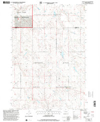
1998 Map of Glad Valley
USGS Topo · Published 2001About this map
Cheyenne River Indian Reservation and the Standing Rock Indian Reservation meet along the Corson and Ziebach county line, forming a landscape shaped by indigenous land history and federal management. The small settlement of Glad Valley serves as a local anchor near the Glad Valley Dam, where the Spillway Elev 721 manages water levels for the surrounding plains. To the northwest, the Grand River National Grassland encompasses a portion of the map, illustrating the region's dedication to prairie conservation. The topography is defined by the drainages of Twin Butte Creek and its East Fork, which carve through the high plains. Evidence of local life and labor appears in the small cemetery and a Gravel Pit, markers of the modest infrastructure required to sustain this rural South Dakota community.
Find a feature on this map
11 named features on this map. Tap any name to fly to it.
Don’t see what you’re looking for? This feature index may not catch every label — zoom into the map to look around manually.
Map Details
Editions of this 1998 Glad Valley Map
This is the sole edition of this map. No revisions or reprints were ever made.
Other maps of this area

1953 · McIntosh
USGS Topo · 1:250,000

1956 · Cottonwood Creek SW
USGS Topo · 1:24,000

1958 · McIntosh
USGS Topo · 1:250,000

1972 · Black Horse Butte
USGS Topo · 1:24,000

1972 · Twin Butte
USGS Topo · 1:24,000

1980 · McIntosh
USGS Topo · 1:100,000

1982 · Glad Valley
USGS Topo · 1:24,000

1982 · Glad Valley SW
USGS Topo · 1:24,000

1982 · Glad Valley NW
USGS Topo · 1:24,000

1982 · Irish Creek SW
USGS Topo · 1:24,000