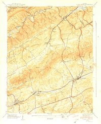
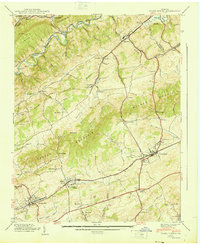
1939 Map of Glade Spring
USGS Topo · Published 1939About this map
Emory and Henry College stands as a focal point in this portion of Washington County and Smyth County, marking a landscape where educational tradition meets a busy rail corridor. The Norfolk and Western railway bisects the valley, connecting significant settlements like Meadow View, Glade Spring, and Emory. The topography is defined by the parallel rises of Little Mountain, Chestnut Ridge, and Walker Mountain, which channel the Lee Highway and the surrounding agricultural activity. Numerous family-named landmarks and cemeteries, such as Snoggrass Cem and Worley Cem, indicate a well-established rural population. Further north, industrial footprints appear near Saltville and Plasterco, including an Aerial Tramway and a Quarry, illustrating the area's diverse economic reliance on both transportation and natural resource extraction during the late 1930s.
Find a feature on this map
78 named features on this map. Tap any name to fly to it.
Don’t see what you’re looking for? This feature index may not catch every label — zoom into the map to look around manually.
Map Details
Editions of this 1939 Glade Spring Map
2 editions found
Other maps of this area

1891 · Abingdon
USGS Topo · 1:125,000

1894 · Abingdon
USGS Topo · 1:125,000

1909 · Abingdon
USGS Topo · 1:96,000

1911 · Abingdon
USGS Topo · 1:125,000

1935 · Konnarock
USGS Topo · 1:24,000

1935 · Chilhowie
USGS Topo · 1:24,000

1935 · Maccrady
USGS Topo · 1:24,000

1935 · Abingdon
USGS Topo · 1:24,000

1935 · Mount Rogers
USGS Topo · 1:48,000

1935 · Saltville
USGS Topo · 1:24,000