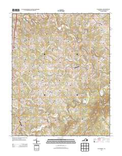
2013 Map of Gladehill
USGS Topo · Published 2013About this map
Pigg River and its numerous tributaries, including Doe Run and Little Chestnut Cr, define the drainage patterns of this Franklin County landscape. The settlement of Gladehill sits in the northeast, while Henry Fork and Sydnorsville anchor the western corridor along the modern highway route. The presence of Hopkins Mill on the river suggests a legacy of early water-powered industry in an area largely characterized by rural farmsteads and family-named roads like Byrds Mill Rd and John Brown Ln.
Find a feature on this map
98 named features on this map. Tap any name to fly to it.
Don’t see what you’re looking for? This feature index may not catch every label — zoom into the map to look around manually.
Map Details
Editions of this 2013 Gladehill Map
This is the sole edition of this map. No revisions or reprints were ever made.
Other maps of this area

1890 · Roanoke
USGS Topo · 1:125,000

1891 · Roanoke
USGS Topo · 1:125,000

1922 · Callands
USGS Topo · 1:48,000

1924 · Callands
USGS Topo · 1:62,500

1925 · Rocky Mount
USGS Topo · 1:48,000

1927 · Rocky Mount
USGS Topo · 1:62,500

1944 · Rocky Mount
USGS Topo · 1:62,500

1944 · Callands
USGS Topo · 1:62,500

1947 · Roanoke
USGS Topo · 1:250,000

1951 · Boones Mill
USGS Topo · 1:62,500