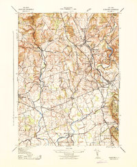
1943 Map of Gladstone
USGS Topo · Published 1943About this map
Gladstone and Peapack form a central hub of settlement in this wartime survey, situated along the Dl & W RR line. The landscape is defined by the steep elevation of Mine Mountain to the north and the winding course of the North Branch Raritan River. This map reveals a transition from the industrial legacy of the northern hills, where several sites like the Wortman Mine, Bartles Mine, and an Iron Mine are located, to the agricultural valleys of Bedminster and Lamington. Educational landmarks like St Bernards School and the Union School reflect the established community life of the early 1940s. To the northwest, the terrain drops sharply into Hacklebarney State Park, where the Lamington River carves through the township border. The presence of numerous smaller hamlets, such as Vliettown and Greater Cross Roads, provides a detailed look at the rural road network before modern suburban expansion.
Find a feature on this map
40 named features on this map. Tap any name to fly to it.
Don’t see what you’re looking for? This feature index may not catch every label — zoom into the map to look around manually.
Map Details
Editions of this 1943 Gladstone Map
This is the sole edition of this map. No revisions or reprints were ever made.
Other maps of this area

1888 · Hackettstown
USGS Topo · 1:62,500

1888 · Lake Hopatcong
USGS Topo · 1:62,500

1890 · High Bridge
USGS Topo · 1:62,500

1891 · Somerville
USGS Topo · 1:62,500

1893 · Somerville
USGS Topo · 1:62,500

1894 · Hackettstown
USGS Topo · 1:62,500

1894 · Lake Hopatcong
USGS Topo · 1:62,500

1898 · Lake Hopatcong
USGS Topo · 1:62,500

1898 · Hackettstown
USGS Topo · 1:62,500

1898 · High Bridge
USGS Topo · 1:62,500
Featured Places
- Bridgewater Township, NJ
- Readington Township, NJ
- Bedminster Township, NJ
- Bernardsville, NJ
- Far Hills, NJ