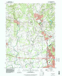
1995 Map of Gladstone
USGS Topo · Published 1998About this map
Pottersville and Gladstone anchor this central New Jersey landscape as it appeared in the mid-1990s, where the rural character of the Lamington River valley meets the growing residential and commercial corridors of Somerset Co and Morris Co counties. The map captures a sophisticated mix of preservation and legacy, from the protected woods of Hacklebarney State Park and the Cold Brook Preserve to established institutions like St Johns Academy and St Bernards Sch.
Find a feature on this map
75 named features on this map. Tap any name to fly to it.
Don’t see what you’re looking for? This feature index may not catch every label — zoom into the map to look around manually.
Map Details
Editions of this 1995 Gladstone Map
This is the sole edition of this map. No revisions or reprints were ever made.
Other maps of this area

1888 · Hackettstown
USGS Topo · 1:62,500

1888 · Lake Hopatcong
USGS Topo · 1:62,500

1890 · High Bridge
USGS Topo · 1:62,500

1891 · Somerville
USGS Topo · 1:62,500

1893 · Somerville
USGS Topo · 1:62,500

1894 · Hackettstown
USGS Topo · 1:62,500

1894 · Lake Hopatcong
USGS Topo · 1:62,500

1898 · Lake Hopatcong
USGS Topo · 1:62,500

1898 · Hackettstown
USGS Topo · 1:62,500

1898 · High Bridge
USGS Topo · 1:62,500
Featured Places
- Bridgewater Township, NJ
- Readington Township, NJ
- Bedminster Township, NJ
- Bernardsville, NJ
- Far Hills, NJ