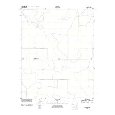
2010 Map of Gladstone
USGS Topo · Published 2010About this map
Gladstone sits at the intersection of several local routes in this northeastern corner of New Mexico, anchored by the Gladstone Post Office and the nearby Gladstone Cemetery. The landscape is defined by the winding course of Ute Creek and the drainage of Sand Arroyo, which cut through the high plains terrain. This 2010 survey illustrates the persistence of small rural settlements like Bryan and Beard, which remain focal points in a region of vast agricultural tracts. The layout of the road network, including County Rd C001 and the crossing of Highway 56 412, reflects a grid-based land division that continues to support the ranching and farming operations characteristic of Union County. For local historians, these specific markers identify the established holdings and community centers that have survived into the modern era.
Find a feature on this map
17 named features on this map. Tap any name to fly to it.
Don’t see what you’re looking for? This feature index may not catch every label — zoom into the map to look around manually.
Map Details
Editions of this 2010 Gladstone Map
This is the sole edition of this map. No revisions or reprints were ever made.
Other maps of this area

1954 · Raton
USGS Topo · 1:250,000

1954 · Dalhart
USGS Topo · 1:250,000

1958 · Raton
USGS Topo · 1:250,000

1958 · Dalhart
USGS Topo · 1:250,000

1962 · Dalhart
USGS Topo · 1:250,000

1973 · Gladstone NW
USGS Topo · 1:24,000

1973 · Sofia
USGS Topo · 1:24,000

1973 · Romero Spring
USGS Topo · 1:24,000

1974 · Farley
USGS Topo · 1:24,000
1974 · Lawrence Arroyo
USGS Topo · 1:24,000