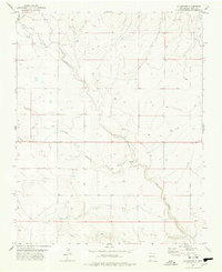
1977 Map of Gladstone
USGS Topo · Published 1978About this map
Gladstone sits at a high-plains crossroads in Union County, centered within a landscape defined by the drainage of Ute Creek and the long, winding Sand Arroyo. In the late 1970s, this area of northeastern New Mexico remained a sparsely populated ranching and farming region, where the small settlement of Bada and the Gladstone Cem serve as key markers for local family history and genealogy. The terrain is etched by seasonal watercourses like Palo Blanco Creek and numerous smaller springs, which dictate the placement of roads and homesteads across the open range. Economic activity is represented by scattered infrastructure such as a Radio Tower and local Gravel Pits, illustrating the practical land use of the High Plains during this era of rural development.
Find a feature on this map
9 named features on this map. Tap any name to fly to it.
Don’t see what you’re looking for? This feature index may not catch every label — zoom into the map to look around manually.
Map Details
Editions of this 1977 Gladstone Map
This is the sole edition of this map. No revisions or reprints were ever made.
Other maps of this area

1954 · Raton
USGS Topo · 1:250,000

1954 · Dalhart
USGS Topo · 1:250,000

1958 · Raton
USGS Topo · 1:250,000

1958 · Dalhart
USGS Topo · 1:250,000

1962 · Dalhart
USGS Topo · 1:250,000

1973 · Gladstone NW
USGS Topo · 1:24,000

1973 · Sofia
USGS Topo · 1:24,000

1973 · Romero Spring
USGS Topo · 1:24,000

1974 · Farley
USGS Topo · 1:24,000
1974 · Lawrence Arroyo
USGS Topo · 1:24,000