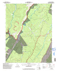
1995 Map of Glady
USGS Topo · Published 1998About this map
The rugged topography of Randolph County is defined here by the parallel ridges of Shavers Mountain and Beech Mountain, creating a landscape dominated by the Monongahela National Forest. Small settlements like Bemis and Glady sit within the river valleys of the Shavers Fork and Glady Fork, connected by a network of forest roads and trails such as the Allegheny Trail. The map documents a transition in land use, where traditional extractive industries like the Strip Mine and other Mines exist alongside the protected expanse of the Laurel Fork North Wilderness. Local genealogy and land use patterns are anchored by features like the Cem near Glady and a Compressor Station along a pipeline corridor, reflecting the industrial footprint within the forest. Numerous drainage runs, including Wolf Run and Spicelick Run, illustrate the complex hydrology of this high-elevation terrain.
Find a feature on this map
50 named features on this map. Tap any name to fly to it.
Don’t see what you’re looking for? This feature index may not catch every label — zoom into the map to look around manually.
Map Details
Editions of this 1995 Glady Map
This is the sole edition of this map. No revisions or reprints were ever made.
Other maps of this area

1889 · Beverly
USGS Topo · 1:125,000

1892 · Beverly
USGS Topo · 1:125,000

1909 · Elkins
USGS Topo · 1:62,500

1922 · Horton
USGS Topo · 1:48,000

1922 · Spruce Knob
USGS Topo · 1:48,000

1922 · Durbin
USGS Topo · 1:48,000

1924 · Durbin
USGS Topo · 1:62,500

1924 · Horton
USGS Topo · 1:62,500

1924 · Spruce Knob
USGS Topo · 1:62,500

1949 · Charlottesville
USGS Topo · 1:250,000