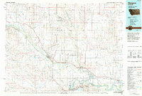
1984 Map of Glasgow
USGS Topo · Published 1984About this map
Glasgow serves as the focal point of this northern Montana landscape, situated at the confluence of Cherry Creek and the Milk River. The map illustrates a region defined by the complex hydrology of the Missouri River basin, where the expansive Fort Peck Indian Reservation dominates the eastern half. To the south, the massive Fort Peck Lake and the Charles M Russell Wildlife Range mark the transition from the river valley to the breaks and coulees.
Find a feature on this map
63 named features on this map. Tap any name to fly to it.
Don’t see what you’re looking for? This feature index may not catch every label — zoom into the map to look around manually.
Map Details
Editions of this 1984 Glasgow Map
This is the sole edition of this map. No revisions or reprints were ever made.
Other maps of this area

1906 · Hinsdale Special Map
USGS Topo · 1:62,500

1910 · Todd Lakes
USGS Topo · 1:62,500

1914 · Nashua
USGS Topo · 1:62,500

1915 · Frazer
USGS Topo · 1:62,500

1915 · Oswego
USGS Topo · 1:62,500

1915 · Todd Lakes
USGS Topo · 1:62,500

1915 · Spring Creek
USGS Topo · 1:62,500

1916 · Nashua
USGS Topo · 1:62,500

1918 · Porcupine Valley
USGS Topo · 1:62,500

1919 · Boundary
USGS Topo · 1:125,000