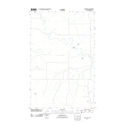
2011 Map of Glass Hill
USGS Topo · Published 2011About this map
West Fork Poplar River meanders through this section of Valley County, Montana, carving a path through the distinct terrain of Happy Valley. The landscape is defined by the convergence of several waterways, including Mosquito Creek and Roanwood Creek, which feed into the primary river system. Human intervention in the natural drainage is evident through structures such as the Professor Pool Dam and Eddie Number 6 Dam, highlighting the management of water resources in this prairie environment.
Find a feature on this map
16 named features on this map. Tap any name to fly to it.
Don’t see what you’re looking for? This feature index may not catch every label — zoom into the map to look around manually.
Map Details
Editions of this 2011 Glass Hill Map
This is the sole edition of this map. No revisions or reprints were ever made.
Other maps of this area

1954 · Glasgow
USGS Topo · 1:250,000

1957 · Glasgow
USGS Topo · 1:250,000

1958 · Glasgow
USGS Topo · 1:250,000

1973 · Glentana West
USGS Topo · 1:24,000

1973 · Opheim
USGS Topo · 1:24,000

1973 · Roanwood
USGS Topo · 1:24,000

1973 · Kaminski Hill
USGS Topo · 1:24,000
1973 · Glentana East
USGS Topo · 1:24,000
1973 · Glass Hill
USGS Topo · 1:24,000

1984 · Opheim
USGS Topo · 1:100,000