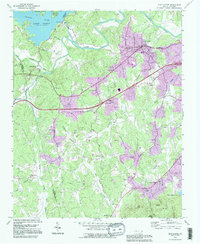
1993 Map of Glen Alpine
USGS Topo · Published 1996About this map
Lake James and the Catawba River dominate the northern landscape of this Burke County region, where the Linnville River flows south past the Linville Dam Powerhouse. The town of Glen Alpine serves as a central hub, situated along the Southern railroad line and surrounded by small rural communities like Parkhill and Bridgewater. This 1990s revision reveals the density of rural social infrastructure, including numerous country churches such as Snow Hill Ch and Mc Elrath Chapel. The rugged topography south of the river is defined by ridges like Bee Ridge and England Knob, with the Pisgah National Forest anchoring the northwestern corner. The map also captures specialized land use in the southeast, notably the State Hospital Reservoir and several small community schools like Pilot Mtn Sch, providing a clear record of the area's mid-to-late 20th-century development.
Find a feature on this map
79 named features on this map. Tap any name to fly to it.
Don’t see what you’re looking for? This feature index may not catch every label — zoom into the map to look around manually.
Map Details
Editions of this 1993 Glen Alpine Map
This is the sole edition of this map. No revisions or reprints were ever made.
Other maps of this area

1905 · Morganton
USGS Topo · 1:125,000

1953 · Charlotte
USGS Topo · 1:250,000

1954 · Charlotte
USGS Topo · 1:250,000

1956 · Oak Hill
USGS Topo · 1:24,000

1956 · Benn Knob
USGS Topo · 1:24,000

1956 · Morganton North
USGS Topo · 1:24,000

1956 · Ashford
USGS Topo · 1:24,000

1956 · Morganton South
USGS Topo · 1:24,000

1956 · Linville Falls
USGS Topo · 1:62,500

1956 · Lenoir
USGS Topo · 1:62,500