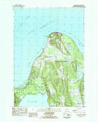
1983 Map of Glen Arbor
USGS Topo · Published 1984About this map
Sleeping Bear Dunes National Lakeshore dominates this coastal landscape along the Lake Michigan shoreline, as recorded during a 1979 field check. The map details the rural character of the Leelanau Peninsula, highlighting the small settlement at Port Oneida and the village of Glen Arbor. The interior is defined by a series of prominent glacial features and freshwater bodies, including the elevated Prospect Hill and the winding Crystal River which connects Fisher Lake toward the lake.
Find a feature on this map
37 named features on this map. Tap any name to fly to it.
Don’t see what you’re looking for? This feature index may not catch every label — zoom into the map to look around manually.
Map Details
Editions of this 1983 Glen Arbor Map
This is the sole edition of this map. No revisions or reprints were ever made.
Other maps of this area

1954 · Traverse City
USGS Topo · 1:250,000

1954 · Escanaba
USGS Topo · 1:250,000

1954 · Manitowoc
USGS Topo · 1:250,000

1955 · Cheboygan
USGS Topo · 1:250,000

1956 · North Manitou
USGS Topo · 1:62,500

1957 · Escanaba
USGS Topo · 1:250,000

1957 · Empire
USGS Topo · 1:62,500

1957 · Maple City
USGS Topo · 1:62,500

1958 · Escanaba
USGS Topo · 1:250,000

1958 · Cheboygan
USGS Topo · 1:250,000