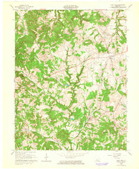
1963 Map of Glen Dean
USGS Topo · Published 1965About this map
The Illinois Central railroad corridor anchors this mid-century view of Breckinridge County, passing through the community of Glen Dean and several Oil Field operations that dot the drainage basins of Black Lick Creek and Clover Creek. Local life at this time centered around widely dispersed rural settlements and their institutions, including St Marys of the Woods Sch near McQuady and Tar Fork Ch to the northwest. The terrain is defined by prominent elevations such as Egypt Knob, Black Jack Knob, and Cretcheloe Hill, which overlook a network of winding waterways and state routes like KY 54. This 1963 revision provides a clear picture of the land just as the Rough River Reservoir began to influence the local hydrology and infrastructure, including a prominent Pumping Station along the rail line.
Find a feature on this map
39 named features on this map. Tap any name to fly to it.
Don’t see what you’re looking for? This feature index may not catch every label — zoom into the map to look around manually.
Map Details
Editions of this 1963 Glen Dean Map
2 editions found
Other maps of this area

1928 · Hardinsburg
USGS Topo · 1:48,000

1931 · Hardinsburg
USGS Topo · 1:62,500

1932 · Fordsville
USGS Topo · 1:62,500

1934 · Cannelton
USGS Topo · 1:62,500

1947 · Hardinsburg
USGS Topo · 1:24,000

1947 · Hardinsburg
USGS Topo · 1:62,500

1953 · Mc Daniels
USGS Topo · 1:24,000

1953 · Hardinsburg
USGS Topo · 1:24,000

1953 · Kingswood
USGS Topo · 1:24,000

1953 · Cloverport
USGS Topo · 1:24,000