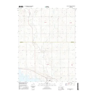
2015 Map of Glen Elder North
USGS Topo · Published 2015About this map
Waconda Lake dominates the southern edge of this landscape, its waters meeting the town of Glen Elder near the Glen Elder Dam Rd. The terrain is defined by a dense network of watercourses that drain the rolling plains of north-central Kansas, including the curiously named Disappointment Cr and the winding channels of Limestone Cr and W Limestone Cr. This survey illustrates the rigid grid of the Public Land Survey System, where local travel follows named routes like Bruce Trl and Alan Trl. For those tracing local heritage, the map identifies rural landmarks such as Athens Cem near the northern boundary and Glenwood Cem to the southeast, providing exact locations for these burial grounds within the agricultural sections of Mitchell and Jewell counties.
Find a feature on this map
24 named features on this map. Tap any name to fly to it.
Don’t see what you’re looking for? This feature index may not catch every label — zoom into the map to look around manually.
Map Details
Editions of this 2015 Glen Elder North Map
This is the sole edition of this map. No revisions or reprints were ever made.
Other maps of this area
1894 · Mankato
USGS Topo · 1:125,000
1894 · Beloit
USGS Topo · 1:125,000
1953 · Solomon Rapids
USGS Topo · 1:24,000
1953 · Waconda Springs
USGS Topo · 1:24,000
1953 · Glen Elder South
USGS Topo · 1:24,000
1955 · Beloit
USGS Topo · 1:250,000
1959 · Beloit
USGS Topo · 1:250,000
1962 · Cawker City
USGS Topo · 1:24,000
1962 · Glen Elder North
USGS Topo · 1:24,000
1962 · Jewell SW
USGS Topo · 1:24,000