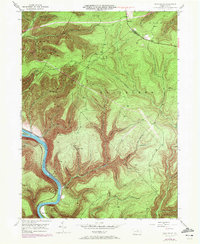
1946 Map of Glen Union
USGS Topo · Published 1972About this map
The West Branch Susquehanna River carves a deep, winding course through this portion of Clinton County, defining the movement and settlement patterns of the mid-20th century. Riverside points like Glen Union and Whetham sit at the base of steep ridges, while the Pipeline cuts a distinct industrial path across the high terrain of Hyner and Gallagher. High points such as the Whetham Fire Tower overlooked the dense forests that would later become part of Bucktail State Park.
Find a feature on this map
35 named features on this map. Tap any name to fly to it.
Don’t see what you’re looking for? This feature index may not catch every label — zoom into the map to look around manually.
Map Details
Editions of this 1946 Glen Union Map
5 editions found

Other maps of this area

1921 · Howard
USGS Topo · 1:48,000

1921 · Lock Haven
USGS Topo · 1:62,500

1923 · Howard
USGS Topo · 1:62,500

1923 · Lock Haven
USGS Topo · 1:62,500

1937 · Waterville
USGS Topo · 1:48,000

1943 · Hyner
USGS Topo · 1:62,500

1943 · Waterville
USGS Topo · 1:62,500

1944 · Lock Haven
USGS Topo · 1:62,500

1946 · Young Womans Creek
USGS Topo · 1:24,000

1946 · Renovo East
USGS Topo · 1:62,500
Featured Places
- Gallagher Township, PA
- Lucullus, McHenry Township
- Ritchie, Grugan Township
- Glen Union, Grugan Township
- McHenry Township, PA