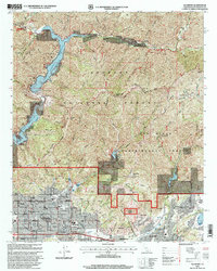
1995 Map of Glendora
USGS Topo · Published 1999About this map
Angeles National Forest dominates the northern landscape of this mid-1990s survey, where the foothills of the San Gabriel Mountains meet the residential expansion of Glendora, San Dimas, and La Verne. The complex water management system of the region is clearly visible, anchored by the San Gabriel Reservoir and Morris Reservoir in the northwest, along with the San Dimas Reservoir and several major dams like Big Dalton Dam.
Find a feature on this map
83 named features on this map. Tap any name to fly to it.
Don’t see what you’re looking for? This feature index may not catch every label — zoom into the map to look around manually.
Map Details
Editions of this 1995 Glendora Map
This is the sole edition of this map. No revisions or reprints were ever made.
Other maps of this area

1894 · Pomona
USGS Topo · 1:62,500

1897 · Pomona
USGS Topo · 1:62,500

1897 · Cucamonga
USGS Topo · 1:62,500

1898 · Pomona
USGS Topo · 1:62,500

1900 · Cucamonga
USGS Topo · 1:62,500

1901 · Southern California Sheet No. 1
USGS Topo · 1:250,000

1903 · Rock Creek
USGS Topo · 1:62,500

1903 · Cucamonga
USGS Topo · 1:62,500

1903 · San Antonio
USGS Topo · 1:62,500

1904 · Pomona
USGS Topo · 1:62,500