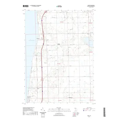
2019 Map of Glenn
USGS Topo · Published 2019About this map
Lake Michigan forms the western boundary of this coastal survey, where the small lakeside communities of Pier Cove, Glenn, and Shorecrest sit along the bluffs. The interior of the quadrangle is defined by a dense grid of rural roads and agricultural plots, punctuated by numerous historic burial grounds that serve as touchstones for local genealogy. Between the orchards and fields, several small waterways including Pier Cove Cr, Plummerville Cr, and Blummerville Cr drain west toward the lake. To the east, the landscape transitions into wetter terrain near Hutchins Lake and the Mud Lake Swamp, marking a shift from the well-drained coastal soils to more complex drainage patterns involving the Ockford Drain. The presence of Grange Corners and Ganges at key intersections illustrates the long-standing importance of these crossroads in the local economy.
Find a feature on this map
68 named features on this map. Tap any name to fly to it.
Don’t see what you’re looking for? This feature index may not catch every label — zoom into the map to look around manually.
Map Details
Editions of this 2019 Glenn Map
This is the sole edition of this map. No revisions or reprints were ever made.
Other maps of this area

1927 · Bangor
USGS Topo · 1:62,500

1927 · South Haven
USGS Topo · 1:62,500

1928 · Fennville
USGS Topo · 1:62,500

1930 · South Haven
USGS Topo · 1:62,500

1931 · Fennville
USGS Topo · 1:62,500

1931 · Bangor
USGS Topo · 1:62,500

1943 · South Haven
USGS Topo · 1:62,500

1943 · Bangor
USGS Topo · 1:62,500

1958 · Racine
USGS Topo · 1:250,000

1962 · Racine
USGS Topo · 1:250,000