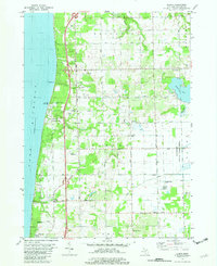
1981 Map of Glenn
USGS Topo · Published 1982About this map
Lake Michigan dominates the western shoreline of this Allegan County landscape, where small settlements like Ganges and Plummerville reflect the agricultural and coastal history of the region. The map reveals a high concentration of burial grounds, including Plummerville Cem, Taylor Cem, and Loomis Cem, which are vital for genealogical research in this part of Michigan. The terrain is marked by the winding course of the Black River and the eastern edge of the Allegan State Game Area, illustrating the balance between managed wilderness and developed farmland.
Find a feature on this map
58 named features on this map. Tap any name to fly to it.
Don’t see what you’re looking for? This feature index may not catch every label — zoom into the map to look around manually.
Map Details
Editions of this 1981 Glenn Map
This is the sole edition of this map. No revisions or reprints were ever made.
Other maps of this area

1927 · Bangor
USGS Topo · 1:62,500

1927 · South Haven
USGS Topo · 1:62,500

1928 · Fennville
USGS Topo · 1:62,500

1930 · South Haven
USGS Topo · 1:62,500

1931 · Fennville
USGS Topo · 1:62,500

1931 · Bangor
USGS Topo · 1:62,500

1943 · South Haven
USGS Topo · 1:62,500

1943 · Bangor
USGS Topo · 1:62,500

1958 · Racine
USGS Topo · 1:250,000

1962 · Racine
USGS Topo · 1:250,000