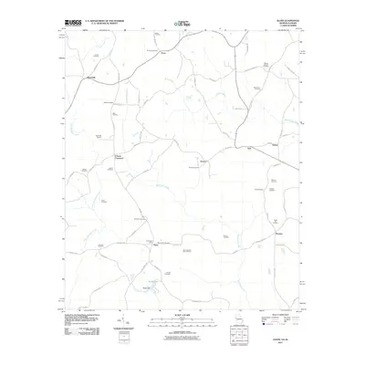
2011 Map of Glenn
USGS Topo · Published 2011About this map
Whitewater Creek and Brush Creek carve through this rural landscape on the Georgia-Alabama border, anchoring a network of small settlements and family-named homesteads. The village of Glenn serves as a local hub, featuring the Glenn Post Office and nearby Mount Zion Cemetery, while other crossroads like Denver, Texas, and Waresville dot the interior. For genealogists and local historians, the sheer density of burial sites—including the State Line Cemetery, Persons Cemetery, and Garrett Cemetery—offers a clear view of the area's ancestral patterns. The terrain is marked by agricultural roads and small water bodies such as Reeds Lake, which is held by Reeds Dam in the southern reaches. From the Panacea Airport in the west to the tiny community of Houston in the east, the map details a quiet, enduring rural infrastructure.
Find a feature on this map
74 named features on this map. Tap any name to fly to it.
Don’t see what you’re looking for? This feature index may not catch every label — zoom into the map to look around manually.
Map Details
Editions of this 2011 Glenn Map
This is the sole edition of this map. No revisions or reprints were ever made.
Other maps of this area

1899 · Wedowee
USGS Topo · 1:125,000

1902 · Wedowee
USGS Topo · 1:125,000

1953 · Atlanta
USGS Topo · 1:250,000

1957 · Atlanta
USGS Topo · 1:250,000

1958 · Atlanta
USGS Topo · 1:250,000
1964 · Abbottsford
USGS Topo · 1:24,000
1964 · La Grange
USGS Topo · 1:24,000

1964 · Glenn
USGS Topo · 1:24,000

1964 · Hillcrest
USGS Topo · 1:24,000
1964 · Franklin
USGS Topo · 1:24,000