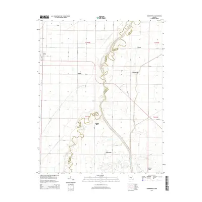
2015 Map of Glennonville
USGS Topo · Published 2015About this map
The Saint Francis River winds through the Missouri Bootheel, defining the boundary between Butler and Dunklin counties. This landscape is a testament to the massive drainage efforts of the early 20th century, where engineered waterways like Ditch Number 31, Ditch Number 34, and Ditch Number 37 transformed former wetlands into productive agricultural territory. Smaller communities and family-named locales are scattered throughout the quadrangle, including Qulin, Glennonville, and Wilhelmina, reflecting the late-era settlement patterns of the region. Local researchers will find specific interest in named sites such as Holmes Place and McElyea Place, which appear alongside remnant natural features like Fish Trap Slough. The intricate network of county roads, including Mo-CC and Mo-JJ, connects these small rural hubs across the flat alluvial plain.
Find a feature on this map
60 named features on this map. Tap any name to fly to it.
Don’t see what you’re looking for? This feature index may not catch every label — zoom into the map to look around manually.
Map Details
Editions of this 2015 Glennonville Map
This is the sole edition of this map. No revisions or reprints were ever made.
Other maps of this area

1935 · Rector
USGS Topo · 1:62,500

1935 · Harviell
USGS Topo · 1:62,500

1940 · Valley Ridge
USGS Topo · 1:62,500

1940 · Piggott
USGS Topo · 1:62,500

1956 · Valley Ridge
USGS Topo · 1:62,500

1956 · Piggott
USGS Topo · 1:62,500

1957 · Poplar Bluff
USGS Topo · 1:250,000

1958 · Rector
USGS Topo · 1:62,500

1959 · Poplar Bluff
USGS Topo · 1:250,000
1960 · Rector
USGS Topo · 1:62,500