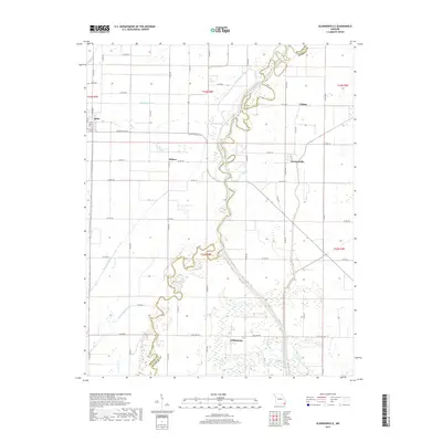
2017 Map of Glennonville
USGS Topo · Published 2017About this map
The Saint Francis River snakes through the heart of this landscape, its winding channel creating a complex boundary between Butler and Dunklin counties. The terrain is defined by a sophisticated water management system, where the natural hydrology is supplemented by numerous drainage features such as Ditch Number 31, Ditch Number 33, and the seasonally variable Fish Trap Slough. This network supported a rural economy centered on small, dispersed communities like Qulin, Glennonville, and Wilhelmina.
Find a feature on this map
63 named features on this map. Tap any name to fly to it.
Don’t see what you’re looking for? This feature index may not catch every label — zoom into the map to look around manually.
Map Details
Editions of this 2017 Glennonville Map
This is the sole edition of this map. No revisions or reprints were ever made.
Other maps of this area

1935 · Rector
USGS Topo · 1:62,500

1935 · Harviell
USGS Topo · 1:62,500

1940 · Valley Ridge
USGS Topo · 1:62,500

1940 · Piggott
USGS Topo · 1:62,500

1956 · Valley Ridge
USGS Topo · 1:62,500

1956 · Piggott
USGS Topo · 1:62,500

1957 · Poplar Bluff
USGS Topo · 1:250,000

1958 · Rector
USGS Topo · 1:62,500

1959 · Poplar Bluff
USGS Topo · 1:250,000
1960 · Rector
USGS Topo · 1:62,500