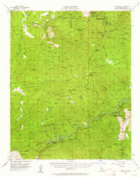
1956 Map of Glennville
USGS Topo · Published 1961About this map
Glennville and the high country of the Sequoia National Forest anchor this mid-century survey of the Greenhorn Mountains. The landscape is defined by the sharp descent from peaks like Black Mtn and Shirley Peak down to the Kern River and Poso Creek. Significant infrastructure for the era is visible, including the Borel Powerhouse and multiple fire lookouts and ranger stations such as the Fulton Ranger Sta and Oak Flat Lookout.
Find a feature on this map
100 named features on this map. Tap any name to fly to it.
Don’t see what you’re looking for? This feature index may not catch every label — zoom into the map to look around manually.
Map Details
Editions of this 1956 Glennville Map
3 editions found
Other maps of this area

1906 · Kernville
USGS Topo · 1:125,000

1908 · Kernville
USGS Topo · 1:125,000

1914 · Caliente
USGS Topo · 1:125,000

1915 · Mojave
USGS Topo · 1:125,000

1920 · Delonagha
USGS Topo · 1:62,500

1926 · Glennville
USGS Topo · 1:62,500

1932 · Woody
USGS Topo · 1:62,500

1935 · Woody
USGS Topo · 1:62,500

1936 · White River
USGS Topo · 1:62,500

1936 · Tobias Peak
USGS Topo · 1:125,000