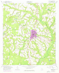
1958 Map of Glennville
USGS Topo · Published 1976About this map
Glennville serves as the central hub of this South Georgia landscape, where the town's grid expands outward into a network of small settlements and agricultural ponds. The influence of the Fort Stewart Military Reservation is felt along the eastern edge, where the Tattnall Co and Long Co line follows the meandering course of Beards Creek. This mid-century survey reveals a rural economy still tied to local milling and forestry, evidenced by features like Edwards Millpond and Dickey Poppell Millpond. Small rural communities like Mendes and Lynn anchor the northwestern reaches, while spiritual life is documented through scattered country churches including Ella Grove Ch and Zaraigh Ch. Of particular interest to genealogists are the historical burial grounds such as Old Halltown Cem and Surrency Cem, which provide clues to early family settlement patterns in this part of Tattnall County.
Find a feature on this map
35 named features on this map. Tap any name to fly to it.
Don’t see what you’re looking for? This feature index may not catch every label — zoom into the map to look around manually.
Map Details
Editions of this 1958 Glennville Map
Other maps of this area

1919 · Claxton
USGS Topo · 1:62,500

1920 · Glennville
USGS Topo · 1:62,500

1944 · Claxton
USGS Topo · 1:62,500

1944 · Glennville
USGS Topo · 1:62,500

1946 · Brunswick
USGS Topo · 1:250,000

1947 · Savannah
USGS Topo · 1:250,000

1948 · Brunswick
USGS Topo · 1:250,000

1948 · Savannah
USGS Topo · 1:250,000

1950 · Glennville
USGS Topo · 1:62,500

1950 · Claxton
USGS Topo · 1:62,500