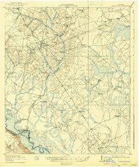
1920 Map of Glennville
USGS Topo · Published 1943About this map
The Altamaha River winds along the southwestern boundary of this 1918-1919 survey, defining a landscape of cypress swamps and river crossings. This era shows the critical transition from river-based transport to regional roads and timber rail, marked by the Beards Bluff Ferry and the Lumber R R. The rural character of Tattnall and Liberty Counties is reflected in the dense network of local schoolhouses that served dispersed farming families, including Rye Patch School, Persimmon Grove School, and Ella Grove School. Small community hubs like Glennville and Mendes are connected by early transit routes such as the Georgia Coast and Piedmont Road. Inland, the terrain is characterized by intricate water systems like Beards Creek and Watermelon Creek, which shaped the placement of early crossings like Halls Bridge and Long Point Bridge.
Find a feature on this map
69 named features on this map. Tap any name to fly to it.
Don’t see what you’re looking for? This feature index may not catch every label — zoom into the map to look around manually.
Map Details
Editions of this 1920 Glennville Map
3 editions found
Other maps of this area

1918 · Jesup
USGS Topo · 1:62,500

1918 · Hinesville
USGS Topo · 1:62,500

1919 · Claxton
USGS Topo · 1:62,500

1920 · Pembroke
USGS Topo · 1:62,500

1920 · Glennville
USGS Topo · 1:62,500

1943 · Ludowici
USGS Topo · 1:62,500

1943 · Jesup
USGS Topo · 1:62,500

1944 · Claxton
USGS Topo · 1:62,500

1944 · Glennville
USGS Topo · 1:62,500

1944 · Hinesville
USGS Topo · 1:62,500