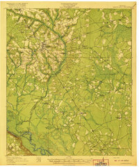
1920 Map of Glennville
USGS Topo · Published 1920About this map
The Altamaha River winds along the southwestern corner of this coastal plain landscape, serving as a historic corridor for transportation evidenced by Beards Bluff Ferry and Tar Landing. The terrain is defined by a dense network of blackwater streams and wetlands, including Beards Creek and Garvan Swamp, which dictated the early settlement patterns of Tattnall and Liberty Counties. This 1918-1919 survey reveals a rural society heavily invested in local education, with nearly two dozen named schoolhouses such as Ella Grove School, Macedonia School, and Appleton School dotting the countryside.
Find a feature on this map
70 named features on this map. Tap any name to fly to it.
Don’t see what you’re looking for? This feature index may not catch every label — zoom into the map to look around manually.
Map Details
Editions of this 1920 Glennville Map
3 editions found
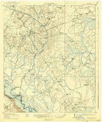
Other maps of this area

1918 · Jesup
USGS Topo · 1:62,500

1918 · Hinesville
USGS Topo · 1:62,500

1919 · Claxton
USGS Topo · 1:62,500

1920 · Pembroke
USGS Topo · 1:62,500

1920 · Glennville
USGS Topo · 1:62,500

1943 · Ludowici
USGS Topo · 1:62,500

1943 · Jesup
USGS Topo · 1:62,500

1944 · Claxton
USGS Topo · 1:62,500

1944 · Glennville
USGS Topo · 1:62,500

1944 · Hinesville
USGS Topo · 1:62,500