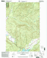
1998 Map of Glenoma
USGS Topo · Published 2003About this map
Glenoma serves as the primary settlement within the fertile Rainey Valley, situated where Rainey Creek meets the northern reaches of Riffe Lake. This landscape is defined by the convergence of several major water systems, including the Tilton River and its various branches, such as the East Fork and South Fork. The topography transitions from the valley floor into the high elevations of the Mt Baker-Snoqualmie National Forest, which is noted here as being administered by the neighboring Gifford Pinchot National Forest. Extensive conservation and recreation areas are present, including the Cowlitz State Wildlife Area and the Glenoma Community Park Picnic Area. Geologic and industrial markers like Coal Canyon and several scattered Quarry sites point to the region's history of resource extraction, while smaller landmarks like Ladd Pond and McKinley Lake punctuate the timbered heights.
Find a feature on this map
26 named features on this map. Tap any name to fly to it.
Don’t see what you’re looking for? This feature index may not catch every label — zoom into the map to look around manually.
Map Details
Editions of this 1998 Glenoma Map
This is the sole edition of this map. No revisions or reprints were ever made.
Other maps of this area

1919 · Mount St Helens
USGS Topo · 1:125,000

1937 · Eatonville
USGS Topo · 1:125,000

1953 · Hoquiam
USGS Topo · 1:250,000

1953 · Elk Rock
USGS Topo · 1:62,500

1956 · Mineral
USGS Topo · 1:62,500

1957 · Hoquiam
USGS Topo · 1:250,000

1957 · Morton
USGS Topo · 1:62,500

1957 · Spirit Lake
USGS Topo · 1:62,500

1958 · Hoquiam
USGS Topo · 1:250,000

1962 · Hoquiam
USGS Topo · 1:250,000