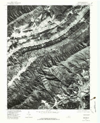
1977 Map of Glenvar
USGS Topo · Published 1983About this map
Glenvar and the surrounding valley floor appear as a distinct corridor of development in this late-1970s orthophotograph, bounded by the steep, wooded slopes of Fort Lewis Mountain and Brush Mountain. The imagery captures a landscape defined by its river systems, where the North Fork Roanoke River and the main stem of the Roanoke River meet near the settlement of Wabun.
Find a feature on this map
13 named features on this map. Tap any name to fly to it.
Don’t see what you’re looking for? This feature index may not catch every label — zoom into the map to look around manually.
Map Details
Editions of this 1977 Glenvar Map
This is the sole edition of this map. No revisions or reprints were ever made.
Other maps of this area

1890 · Christiansburg
USGS Topo · 1:125,000

1923 · Waiteville
USGS Topo · 1:62,500

1929 · Salem
USGS Topo · 1:48,000

1931 · Waiteville
USGS Topo · 1:48,000

1932 · Salem
USGS Topo · 1:62,500

1932 · Blacksburg
USGS Topo · 1:48,000

1937 · Blacksburg
USGS Topo · 1:62,500

1944 · Waiteville
USGS Topo · 1:62,500

1950 · Elliston
USGS Topo · 1:62,500

1951 · Waiteville
USGS Topo · 1:62,500