1944 Map of Waiteville
USGS Topo · Published 1944About this map
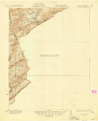
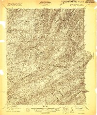
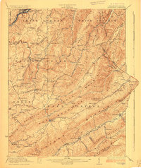
Waiteville serves as a focal point along the border of Virginia and West Virginia, illustrating the rugged frontier geography of the Ridge-and-Valley Appalachians. Based on surveys from 1921 and 1931, the map highlights a landscape dominated by massive ridges like Peters Mountain and Potts Mountain. A clear signature of the era's changing industrial landscape is found in the Norfolk and Western Ry line, which is marked as Abandoned as it snakes alongside Potts Cr.
Find a feature on this map
37 named features on this map. Tap any name to fly to it.
Don’t see what you’re looking for? This feature index may not catch every label — zoom into the map to look around manually.
Map Details
Editions of this 1944 Waiteville Map
This is the sole edition of this map. No revisions or reprints were ever made.
Other maps of this area

1887 · Hinton
USGS Topo · 1:125,000

1887 · Lewisburg
USGS Topo · 1:125,000

1890 · Dublin
USGS Topo · 1:125,000

1890 · Christiansburg
USGS Topo · 1:125,000

1891 · Lewisburg
USGS Topo · 1:125,000

1891 · Dublin
USGS Topo · 1:125,000

1892 · Hinton
USGS Topo · 1:125,000

1921 · Alderson
USGS Topo · 1:48,000
1921 · Ronceverte
USGS Topo · 1:48,000
1923 · Ronceverte
USGS Topo · 1:62,500