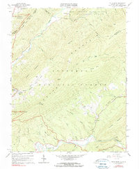
1966 Map of Potts Creek
USGS Topo · Published 1990About this map
Sweet Springs and the surrounding mountain ridges define this landscape along the border of Virginia and West Virginia during the mid-1960s. The area is dominated by the Jefferson National Forest, where steep terrain is marked by significant landmarks like Potts Mountain and Hanging Rock. Local life is anchored by small rural institutions such as Paxton Chapel and Mt Olivet Ch, along with numerous family burial grounds including Nutter Cem and Ruble Cem. A notable industrial and conservation presence is found at the Paint Bank National Fish Hatchery near the western edge of the sheet. The drainage patterns of Potts Creek and Johns Creek suggest a remote, highland economy where transport followed narrow valley floors like Red Brush Valley Branch, connecting isolated settlements and mountain gaps through a network of jeep trails and forest roads.
Find a feature on this map
62 named features on this map. Tap any name to fly to it.
Don’t see what you’re looking for? This feature index may not catch every label — zoom into the map to look around manually.
Map Details
Editions of this 1966 Potts Creek Map
2 editions found
Other maps of this area

1887 · Lewisburg
USGS Topo · 1:125,000

1890 · Christiansburg
USGS Topo · 1:125,000

1891 · Lewisburg
USGS Topo · 1:125,000

1921 · Ronceverte
USGS Topo · 1:48,000

1923 · Ronceverte
USGS Topo · 1:62,500

1923 · Waiteville
USGS Topo · 1:62,500

1929 · Salem
USGS Topo · 1:48,000

1931 · Waiteville
USGS Topo · 1:48,000

1932 · Salem
USGS Topo · 1:62,500

1944 · Waiteville
USGS Topo · 1:62,500