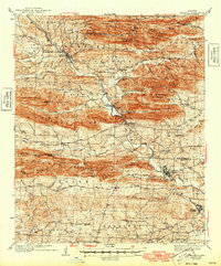
1942 Map of Glenwood
USGS Topo · Published 1949About this map
The Caddo River carves a deep path through the heart of the Ouachita National Forest in this mid-century survey of western Arkansas. This landscape is defined by the heavy ridges of the Cossatot Mountains and the Crystal Mountains, where the Missouri Pacific railroad follows the river valley to connect the settlements of Norman and Glenwood. The map captures a transition in local infrastructure, showing the Womble Ranger Sta and numerous rural institutions like the Caddo Hill Sch and Shockley Chapel. The density of cemeteries, including the Nelson Cem and Powers Chapel Cem, provides a detailed record of family names and early community nodes. To the south, the terrain levels out toward the Antoine Mountains, where the small rail stop of Rosboro and the rural hamlet of Manfred sit along the winding watercourses.
Find a feature on this map
89 named features on this map. Tap any name to fly to it.
Don’t see what you’re looking for? This feature index may not catch every label — zoom into the map to look around manually.
Map Details
Editions of this 1942 Glenwood Map
4 editions found
Other maps of this area

1890 · Mount Ida
USGS Topo · 1:125,000

1890 · Hot Springs
USGS Topo · 1:125,000

1894 · Hot Springs
USGS Topo · 1:125,000

1906 · Caddo Gap
USGS Topo · 1:125,000

1936 · Athens
USGS Topo · 1:48,000

1936 · Glenwood
USGS Topo · 1:48,000

1942 · Glenwood
USGS Topo · 1:62,500

1942 · Athens
USGS Topo · 1:62,500

1943 · Antoine
USGS Topo · 1:62,500

1949 · Glenwood
USGS Topo · 1:62,500