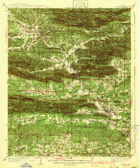
1942 Map of Glenwood
USGS Topo · Published 1942About this map
The Caddo River carves a path through the formidable ridges of the Ouachita Mountains on this 1930s-era survey, revealing a landscape defined by sharp elevation changes and riverside settlements. Along the banks, towns like Norman and Caddo Gap serve as focal points for local commerce, connected by the vital Missouri Pacific railroad line that snakes through the mountain passes. The map documents the extensive reach of the Ouachita National Forest, where steep ranges such as the Caddo Mountains and Fodderstack Range dominate the topography.
Find a feature on this map
53 named features on this map. Tap any name to fly to it.
Don’t see what you’re looking for? This feature index may not catch every label — zoom into the map to look around manually.
Map Details
Editions of this 1942 Glenwood Map
4 editions found
Other maps of this area

1890 · Mount Ida
USGS Topo · 1:125,000

1890 · Hot Springs
USGS Topo · 1:125,000

1894 · Hot Springs
USGS Topo · 1:125,000

1906 · Caddo Gap
USGS Topo · 1:125,000

1936 · Athens
USGS Topo · 1:48,000

1936 · Glenwood
USGS Topo · 1:48,000

1942 · Glenwood
USGS Topo · 1:62,500

1942 · Athens
USGS Topo · 1:62,500

1943 · Antoine
USGS Topo · 1:62,500

1949 · Glenwood
USGS Topo · 1:62,500