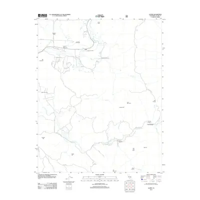
2012 Map of Globe
USGS Topo · Published 2012About this map
The settlement of Globe and the surrounding Sierra Nevada foothills are defined by a complex network of historic water management in this 2012 survey. Early irrigation and drainage systems like the Pleasant Valley Ditch, Moore-Witt Ditch, and Graham-Osborn Ditch illustrate how water was diverted from the Tule River to support the local landscape. The terrain rises sharply to the east toward Cow Mountain and Oat Mountain, while the southern portion of the quadrangle is marked by the Indian Reservation Rd near the S Fork Tule River. This modern era map provides a clear view of local infrastructure, from the Springville District Ranger Office to the remote reaches of Blue Canyon and Gibbon Canyon, recording the persistent footprint of mountain settlements and family-named landmarks like Bonsall Hill and Bagby Hill.
Find a feature on this map
59 named features on this map. Tap any name to fly to it.
Don’t see what you’re looking for? This feature index may not catch every label — zoom into the map to look around manually.
Map Details
Editions of this 2012 Globe Map
This is the sole edition of this map. No revisions or reprints were ever made.
Other maps of this area

1904 · Kaweah
USGS Topo · 1:125,000

1909 · Kaweah
USGS Topo · 1:125,000

1936 · White River
USGS Topo · 1:62,500

1936 · Tobias Peak
USGS Topo · 1:125,000

1937 · Kaweah
USGS Topo · 1:125,000

1943 · Tobias Peak
USGS Topo · 1:125,000

1945 · Tobias Peak
USGS Topo · 1:62,500

1948 · Bakersfield
USGS Topo · 1:250,000

1948 · Fresno
USGS Topo · 1:250,000
1952 · White River
USGS Topo · 1:62,500