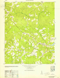
1953 Map of Gloucester
USGS Topo · Published 1953About this map
Low-lying Tidewater terrain and extensive wetlands characterize this mid-century survey, where the winding networks of Beaverdam Swamp and Beech Swamp define the inland landscape. The village of Gloucester serves as the central hub, surrounded by smaller crossroads and settlements such as Sassafras, Belroi, and Bacons Quarters. The transportation network is anchored by the George Washington Memorial Highway and the Tidewater Trail, reflecting the importance of road travel through the coastal plain as local industry relied on routes like Fiddlers Bridge Road.
Find a feature on this map
46 named features on this map. Tap any name to fly to it.
Don’t see what you’re looking for? This feature index may not catch every label — zoom into the map to look around manually.
Map Details
Editions of this 1953 Gloucester Map
This is the sole edition of this map. No revisions or reprints were ever made.
Other maps of this area

1906 · Williamsburg
USGS Topo · 1:62,500

1916 · Kilmarnock
USGS Topo · 1:48,000

1916 · Mathews
USGS Topo · 1:62,500

1917 · Urbanna
USGS Topo · 1:62,500

1917 · Kilmarnock
USGS Topo · 1:62,500

1917 · Mathews
USGS Topo · 1:62,500

1942 · Kilmarnock
USGS Topo · 1:62,500

1943 · Richmond
USGS Topo · 1:250,000

1948 · Ware Neck
USGS Topo · 1:24,000

1948 · Achilles
USGS Topo · 1:24,000