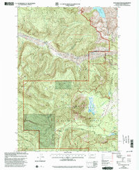
2000 Map of Goat Mountain
USGS Topo · Published 2003About this map
Mount St Helens National Volcanic Monument and the surrounding Gifford Pinchot National Forest define this landscape just two decades after the cataclysmic eruption. The drainage of the South Fork Toutle River dominates the northern half of the sheet, where debris and volcanic flows have permanently altered the course of waterways like Castle Lake.
Find a feature on this map
22 named features on this map. Tap any name to fly to it.
Don’t see what you’re looking for? This feature index may not catch every label — zoom into the map to look around manually.
Map Details
Editions of this 2000 Goat Mountain Map
This is the sole edition of this map. No revisions or reprints were ever made.
Other maps of this area

1919 · Mount St Helens
USGS Topo · 1:125,000

1953 · Hoquiam
USGS Topo · 1:250,000

1953 · Cougar
USGS Topo · 1:62,500

1953 · Elk Rock
USGS Topo · 1:62,500

1957 · Hoquiam
USGS Topo · 1:250,000

1957 · Spirit Lake
USGS Topo · 1:62,500

1958 · Mt St. Helens
USGS Topo · 1:62,500

1958 · Hoquiam
USGS Topo · 1:250,000

1962 · Hoquiam
USGS Topo · 1:250,000
1975 · Spirit Lake SW
USGS Topo · 1:24,000