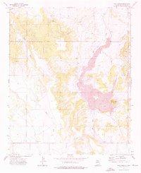
1972 Map of Goat Spring
USGS Topo · Published 1976About this map
Lava flows dominate the central and eastern portions of this Catron County landscape, creating a stark geological contrast with the surrounding high desert terrain. In the early 1970s, this area remained largely defined by its water sources and volcanic features, with Goat Spring and the drainage of Agua Fria Creek providing critical points of reference in an otherwise arid environment. The presence of Red Cone Hill and the sprawling basalt fields illustrate the volcanic history that shaped the local topography.
Find a feature on this map
13 named features on this map. Tap any name to fly to it.
Don’t see what you’re looking for? This feature index may not catch every label — zoom into the map to look around manually.
Map Details
Editions of this 1972 Goat Spring Map
This is the sole edition of this map. No revisions or reprints were ever made.
Other maps of this area

1886 · St Johns
USGS Topo · 1:250,000

1892 · St Johns
USGS Topo · 1:250,000

1954 · Saint Johns
USGS Topo · 1:250,000

1955 · Red Hill
USGS Topo · 1:24,000

1957 · Saint Johns
USGS Topo · 1:250,000

1958 · Saint Johns
USGS Topo · 1:250,000

1962 · Saint Johns
USGS Topo · 1:250,000
1968 · Nelson Reservoir NE
USGS Topo · 1:24,000

1971 · Mesa Parada
USGS Topo · 1:24,000
1971 · The Rincon
USGS Topo · 1:24,000