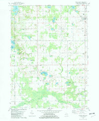
1981 Map of Gobles West
USGS Topo · Published 1982About this map
Gobles serves as the primary hub in this corner of Van Buren County, showing a late-twentieth-century landscape defined by an extensive network of kettle lakes and drainages. The map details a transition from the village center near Wesler Airfield to the smaller crossroads of Glendale and Armstrong Corners. Water dominates the terrain, with large bodies like Great Bear Lake and School Section Lake joined by smaller named features such as Abernathy Lake and Thayer Lake.
Find a feature on this map
49 named features on this map. Tap any name to fly to it.
Don’t see what you’re looking for? This feature index may not catch every label — zoom into the map to look around manually.
Map Details
Editions of this 1981 Gobles West Map
This is the sole edition of this map. No revisions or reprints were ever made.
Other maps of this area

1927 · Hartford
USGS Topo · 1:62,500

1927 · Bangor
USGS Topo · 1:62,500

1931 · Bangor
USGS Topo · 1:62,500

1931 · Hartford
USGS Topo · 1:62,500

1943 · Bangor
USGS Topo · 1:62,500

1944 · Marcellus
USGS Topo · 1:62,500

1946 · Marcellus
USGS Topo · 1:62,500

1946 · Gobles
USGS Topo · 1:62,500

1948 · Gobles
USGS Topo · 1:62,500

1949 · Gobles
USGS Topo · 1:62,500