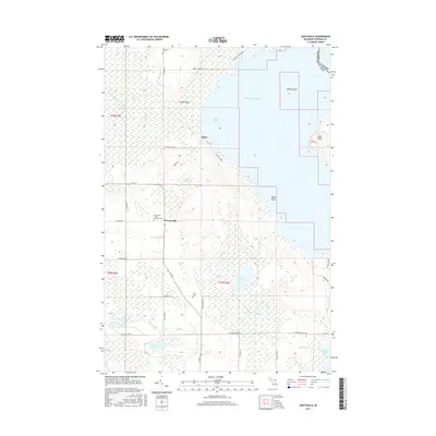
2017 Map of Goetzville
USGS Topo · Published 2017About this map
Munuscong Lake and the international waters of Raber Bay define this borderland region where the Upper Peninsula of Michigan meets Ontario, Canada. The settlement of Goetzville serves as a focal point for the interior, home to the Goetzville / Saint Stanislaus Cem, while the hamlet of Raber sits further north near the shoreline. The landscape is a mosaic of lowland hydrology and modest family landmarks, characterized by the expansive Gogomain Swamp and numerous smaller water bodies such as Caribou Lake, Ziegler Lake, and Carlton Lake. Surveyed roads like S Raber Rd and E M 48 provide the primary grid through this heavily forested and marshy terrain. Genealogists can identify several burial sites including Anderson Cem and Little Cem, which alongside the named islands of Lime Island and Round Island, offer a clear picture of the area's rural development and geographic isolation at the time of this 2017 survey.
Find a feature on this map
46 named features on this map. Tap any name to fly to it.
Don’t see what you’re looking for? This feature index may not catch every label — zoom into the map to look around manually.
Map Details
Editions of this 2017 Goetzville Map
This is the sole edition of this map. No revisions or reprints were ever made.
Other maps of this area

1953 · Munuscong
USGS Topo · 1:24,000

1953 · Munuscong NE
USGS Topo · 1:24,000

1954 · Alpena
USGS Topo · 1:250,000

1954 · Sault Sainte Marie
USGS Topo · 1:250,000

1955 · Cheboygan
USGS Topo · 1:250,000

1956 · Sault Sainte Marie
USGS Topo · 1:250,000

1957 · Alpena
USGS Topo · 1:250,000

1957 · Sault Sainte Marie
USGS Topo · 1:250,000

1958 · Cheboygan
USGS Topo · 1:250,000

1958 · Alpena
USGS Topo · 1:250,000