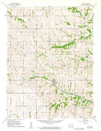
1961 Map of Goff
USGS Topo · Published 1962About this map
Goff serves as the central hub of this northern Kansas landscape, situated at a key juncture of the Missouri Pacific railroad. The town's layout and surrounding rural townships, including Harrison and Granada, reveal a classic Midwestern agricultural settlement pattern defined by section lines and creek-side cemeteries. Local history is etched into the terrain through sites like St Bedes Cem in the northwest and Barnes Cem to the east. The drainage of Tennessee Creek and Barnes Creek cuts through the prairie, while localized industry is evidenced by Gravel Pits found along the rail line west of the town center. This survey captures the region just as modern infrastructure was solidifying around long-established rural landmarks.
Find a feature on this map
15 named features on this map. Tap any name to fly to it.
Don’t see what you’re looking for? This feature index may not catch every label — zoom into the map to look around manually.
Map Details
Editions of this 1961 Goff Map
This is the sole edition of this map. No revisions or reprints were ever made.
Other maps of this area

1888 · Hiawatha
USGS Topo · 1:125,000

1889 · Seneca
USGS Topo · 1:125,000

1894 · Seneca
USGS Topo · 1:125,000

1894 · Hiawatha
USGS Topo · 1:125,000

1950 · Kansas City
USGS Topo · 1:250,000

1954 · Kansas City
USGS Topo · 1:250,000

1955 · Manhattan
USGS Topo · 1:250,000

1956 · Manhattan
USGS Topo · 1:250,000

1956 · Kansas City
USGS Topo · 1:250,000

1957 · Manhattan
USGS Topo · 1:250,000