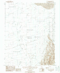
1988 Map of Gold Flat East
USGS Topo · Published 1988About this map
Nellis Air Force Range (Restricted Area) dominates this section of the Nye County desert, where military activity and conservation management overlap. The terrain is characterized by broad alluvial fans and significant topographic low points labeled as Depression, leading into the wide expanse of Gold Flat. To the east, the landscape rises sharply into the Nevada Wild Horse Management Area, where an Indefinite Boundary marks the transition from the range's restricted operations to protected lands. The presence of several Target markers and an Abandoned Target reflect the area's intensive use for aerial training exercises. Natural features are scarce in this arid environment, though Grass Spring Canyon provides a named landmark amidst the rugged eastern slopes.
Find a feature on this map
9 named features on this map. Tap any name to fly to it.
Don’t see what you’re looking for? This feature index may not catch every label — zoom into the map to look around manually.
Map Details
Editions of this 1988 Gold Flat East Map
This is the sole edition of this map. No revisions or reprints were ever made.
Other maps of this area

1908 · Kawich
USGS Topo · 1:250,000

1942 · Tolicha Peak
USGS Topo · 1:125,000

1942 · Cactus Range
USGS Topo · 1:125,000

1942 · Reveille Peak
USGS Topo · 1:125,000

1942 · Wheelbarrow Peak
USGS Topo · 1:125,000

1952 · Mellan
USGS Topo · 1:62,500

1952 · Quartzite Mtn
USGS Topo · 1:62,500

1952 · Silent Canyon
USGS Topo · 1:62,500
1952 · Black Mtn
USGS Topo · 1:62,500

1954 · Goldfield
USGS Topo · 1:250,000