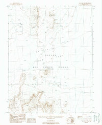
1988 Map of Gold Flat West
USGS Topo · Published 1988About this map
Nellis Air Force Range dominates this landscape in the late 1980s, revealing a high-desert environment heavily modified for military testing and observation. The map shows an extensive network of Targets and observation points spread across the dry expanse of Gold Flat and the adjacent Depression. This area, restricted from public access, contains several interesting utilitarian features including a lonely Graveyard located near the northern edge of the flats. Along the western edge, the terrain rises into the Coyote Cuesta, providing a stark contrast to the level basin floor. Industrial activity is represented by several excavations, specifically Pits 1, Pits 2, and Pits 3, which underscore the human impact on this isolated stretch of Nye County.
Find a feature on this map
10 named features on this map. Tap any name to fly to it.
Don’t see what you’re looking for? This feature index may not catch every label — zoom into the map to look around manually.
Map Details
Editions of this 1988 Gold Flat West Map
This is the sole edition of this map. No revisions or reprints were ever made.
Other maps of this area

1908 · Kawich
USGS Topo · 1:250,000

1942 · Tolicha Peak
USGS Topo · 1:125,000

1942 · Cactus Range
USGS Topo · 1:125,000

1942 · Reveille Peak
USGS Topo · 1:125,000

1942 · Wheelbarrow Peak
USGS Topo · 1:125,000

1952 · Mellan
USGS Topo · 1:62,500

1952 · Quartzite Mtn
USGS Topo · 1:62,500

1952 · Silent Canyon
USGS Topo · 1:62,500
1952 · Black Mtn
USGS Topo · 1:62,500

1954 · Goldfield
USGS Topo · 1:250,000