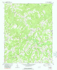
1978 Map of Gold Sand
USGS Topo · Published 1989About this map
Gold Sand and White Level serve as the primary hubs for this rural landscape along the Warren and Franklin county line. The terrain is defined by the winding paths of Sandy Creek and Sycamore Creek, which are surrounded by numerous small community centers and rural homesteads. This 1970s survey illustrates a densely settled agricultural region, where the social fabric is anchored by local institutions like Jones Chapel, Mountain Grove Ch, and Mt Gilead Ch.
Find a feature on this map
26 named features on this map. Tap any name to fly to it.
Don’t see what you’re looking for? This feature index may not catch every label — zoom into the map to look around manually.
Map Details
Editions of this 1978 Gold Sand Map
2 editions found
Other maps of this area

1953 · Greensboro
USGS Topo · 1:250,000

1954 · Greensboro
USGS Topo · 1:250,000

1962 · Greensboro
USGS Topo · 1:250,000

1966 · Greensboro
USGS Topo · 1:250,000

1970 · Vicksboro
USGS Topo · 1:24,000

1971 · Inez
USGS Topo · 1:24,000

1971 · Afton
USGS Topo · 1:24,000
1978 · Gold Sand
USGS Topo · 1:24,000
1978 · Louisburg
USGS Topo · 1:24,000
1978 · Centerville
USGS Topo · 1:24,000