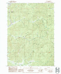
1986 Map of Golden
USGS Topo · Published 1986About this map
Golden and Placer stand as focal points in this 1986 survey of the mining-heavy landscape along the Douglas Co Josephine Co border. The map reveals an intricate network of mineral claims and operations, notably the Greenback Mine and Anaconda Mine in the central hills. These sites, along with others like the MacAbee Mine and Morning Star Mine, illustrate a legacy of extraction near the waters of Coyote Creek and Wolf Creek. Infrastructure such as the Stage Road and a high-elevation Pipeline suggest the logistical demands of these remote operations. Significant landmarks for local history include a Cemetery near Placer and the prominent heights of St Paul Mountain and St Peter Mountain, which overlook the surrounding gulches and reservoirs like Secesh Reservoir.
Find a feature on this map
71 named features on this map. Tap any name to fly to it.
Don’t see what you’re looking for? This feature index may not catch every label — zoom into the map to look around manually.
Map Details
Editions of this 1986 Golden Map
This is the sole edition of this map. No revisions or reprints were ever made.
Other maps of this area

1904 · Riddle
USGS Topo · 1:125,000

1954 · Days Creek
USGS Topo · 1:62,500

1954 · Glendale
USGS Topo · 1:62,500

1954 · Wimer
USGS Topo · 1:62,500

1954 · Canyonville
USGS Topo · 1:62,500

1955 · Medford
USGS Topo · 1:250,000

1957 · Medford
USGS Topo · 1:250,000

1958 · Medford
USGS Topo · 1:250,000
1983 · Wimer
USGS Topo · 1:24,000
1983 · King Mountain
USGS Topo · 1:24,000